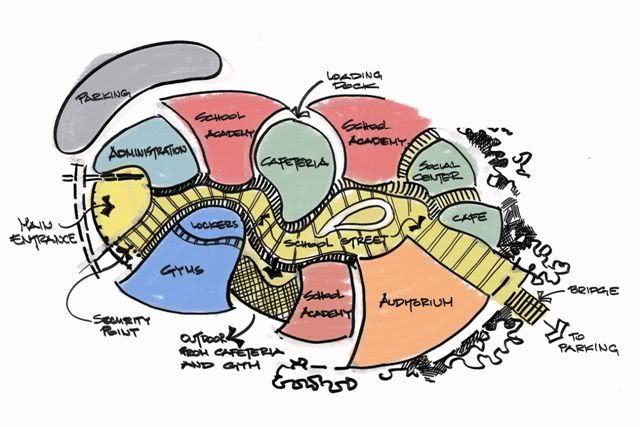
Spatial diagram
A spatial diagram, or spatial plan, can be used to investigate or illustrate the future spatial development of an area. It communicates a development concept as physical spatial elements and demonstrates how extending and developing spatial uses and infrastructure can shape a location, district or region.
The development of spatial diagrams requires imaginative and innovative ideas. Inspiration for developing a spatial diagram is often drawn from the results of other district or regional analysis methods.
A spatial diagram may give indications as to the highest priority areas to be developed, as well as decisions on the settlement pattern for development in the future. Approximate scales are used for the diagram in order to avoid committing to detail. More specific land use plans are developed once a decision has been taken to implement certain elements of a diagram.
A spatial diagram is not constrained by time, but is designed to be a flexible model, capable of providing guidance and information to urban planners and decision-makers in optimising investment. Such investment can encourage and enable economic and social development, and may result in the progressive delivery of the spatial diagram over time.
Investment decisions are often taken, particularly effecting urban centres, with consideration of functional specialisation to avoid too much competition and duplication, which can lead to a decline in markets or services. Spatial diagrams can be used to assist in this planning work, with what is termed a 'settlement pattern'. This indicates issues such as whether or not the economies of the main urban centres are to be further developed or consolidated, whether urban specialisation should be either maintained or encouraged, and so on.
As well as the settlement pattern, information that is often provided on a spatial diagram may include:
- Road networks.
- The land use system.
- Conservation areas.
- Areas where development is to be restricted or controlled.
Some of the benefits of using a spatial diagram include:
- It is a useful method for reviewing proposed development policies and how they may interrelate functionally with ‘space’.
- It provides a framework for guiding an area’s development.
- It can coordinate development activities undertaken by different planning institutions, organisations or departments.
- It can provide guidance to decision-makers and planners about strategic investment decisions.
Some of the limitations of using a spatial diagram include:
- Spatial diagrams do not contain a time line for development.
- The costs and resource mobilisation required are not illustrated, and so, unless previous analytical steps, such as demographic projections and locational evaluations, have been undertaken, the diagram can be misleading.
- There is the risk that spatial diagrams can be interpreted as masterplans, rather than just being used to guide development decisions.
[edit] Related articles on Designing Buildings Wiki
Featured articles and news
Ebenezer Howard: inventor of the garden city. Book review.
The Grenfell Tower fire, eight years on
A time to pause and reflect as Dubai tower block fire reported just before anniversary.
Airtightness Topic Guide BSRIA TG 27/2025
Explaining the basics of airtightness, what it is, why it's important, when it's required and how it's carried out.
Construction contract awards hit lowest point of 2025
Plummeting for second consecutive month, intensifying concerns for housing and infrastructure goals.
Understanding Mental Health in the Built Environment 2025
Examining the state of mental health in construction, shedding light on levels of stress, anxiety and depression.
The benefits of engaging with insulation manufacturers
When considering ground floor constructions.
Lighting Industry endorses Blueprint for Electrification
The Lighting Industry Association fully supports the ECA Blueprint as a timely, urgent call to action.
BSRIA Sentinel Clerk of Works Training Case Study
Strengthening expertise to enhance service delivery with integrated cutting-edge industry knowledge.
Impact report from the Supply Chain Sustainability School
Free sustainability skills, training and support delivered to thousands of UK companies to help cut carbon.
The Building Safety Forum at the Installershow 2025
With speakers confirmed for 24 June as part of Building Safety Week.
The UK’s largest air pollution campaign.
Future Homes Standard, now includes solar, but what else?
Will the new standard, due to in the Autumn, go far enough in terms of performance ?
BSRIA Briefing: Cleaner Air, Better tomorrow
A look back at issues relating to inside and outside air quality, discussed during the BSRIA briefing in 2023.
Restoring Abbotsford's hothouse
Bringing the writer Walter Scott's garden to life.
Reflections on the spending review with CIAT.
Retired firefighter cycles world to raise Grenfell funds
Leaving on 14 June 2025 Stephen will raise money for youth and schools through the Grenfell Foundation.
Key points for construction at a glance with industry reactions.


